
Sugar Loaf – Mackinac Island
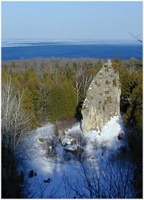 The dramatic breccia mass rises 75 feet above the ground and is the largest of Mackinac Island’s many limestone stacks.
Centuries ago a huge lake that geologist call Lake Algonquin covered all but the center of Mackinac Island. Sugar Loaf was then a small, eroding island cut off from the surrounding land area. When the water receded, the stack was left standing as a tower of rock.
East side of island a short distance inland from the shoreline, Located on Sugar Loaf Road at Point Lookout.
Sugar Loaf via Wikipedia
Sugar Loaf is a 75-foot-high (23m) landlocked rock or stack in the interior of Mackinac Island in Lake Huron. Created by erosion during the period of postglacial Lake Algonquin, Sugar Loaf is the largest post-glacial erosion feature in the Straits of Mackinac.
The immense rock, which consists of resistant limestone breccia, was cut off from Ancient Mackinac Island or the Turtle’s Back by the glacial meltwaters of Lake Algonquin. Polar storms released by the retreating ice sheet created erosional forces much stronger than any existing today on the Great Lakes.
The rock lies within the boundaries of the Mackinac Island State Park near the junction of Crooked Tree Road and Sugar Loaf Road. It can be seen from Point Lookout, near the Island’s highest point. – >> Read More on Wikipedia >>
<>
Sugar Loaf On Mackinac Island – Photos From Instagram
Here are the latest photos of Sugar Loaf via instagram. If you have an instagram photo to share of your visit to Sugar Loaf, choose “Sugar Loaf” as your location and your photos will appear in the photo stream below.
Error: No feed type selected. Please use a feed type of "user", "hashtag", or "mixed".
<>
<>
Sugar Loaf & Mackinac Island Natural Wonders – Mackinac Island State Park >>>>
<>